Google Maps updates multiple functions, more traffic information - Age1983
Whether you are a salaried worker + bus commuter in a bustling city, or a white-collar worker + driver navigating through heavy traffic, you can now use Google Maps to check urban roads, public transportation options, or even detailed driving routes for intra-city or inter-provincial travel.
Google Maps' public transit search function now covers 81 cities and 38,000 transit routes nationwide. Let's take a hands-on experience of the new Google Maps service.
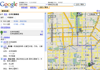
Public Transit Search Expanded to 81 Cities
If you're in Beijing and want to find the route from "Beijing Railway Station" to "Olympic Park," select "Public Transportation Route" in the left-hand "Search Results" column. You will then see detailed suggestions for buses and subways, including clearly marked start and end stops for each bus segment, the distance traveled, and the entire route displayed both in the search results and on the map. Additionally, we offer you two options: "Faster" or "Fewer Transfers."