Apple iPhone Beta Firmware Adds Geo-tagging and Location Services
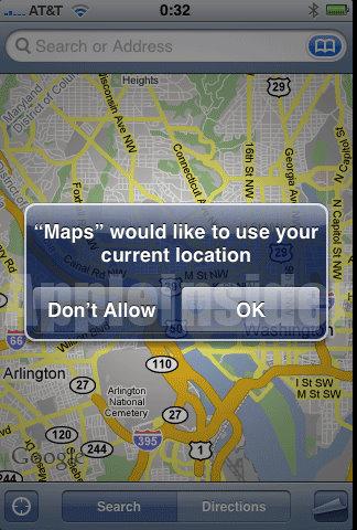
Apple has distributed the iPhone 2.0 test firmware with version number 5A292g to some enterprise partners, introducing an interesting new feature that allows the built-in camera to add Geo-Tagging geotags containing the latitude and longitude of where the photo was taken.
The officially released iPhone 2.0 firmware expected next month will fully integrate location services, including built-in Google Maps and photography geotagging. Apple has even added a general location service switch in the settings menu.
After enabling this function, every photo taken by the user will be tagged with local latitude, longitude, and even place names. In the future, users can classify and search by location, and also view photos on a map according to their travel order, which can add many interesting applications. Below is the operation interface.