The 2009 Total Solar Eclipse Path over Mainland China on Google Maps
by freezeblue on 2009-07-17 16:14:45
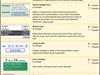
This Google Map image shows the path of totality for the July 22, 2009 total solar eclipse as it crossed mainland China. The blue north-south path lines mark the boundaries of the total eclipse zone, while the red centerline indicates the center of the total eclipse. The yellow lines crossing the path of totality represent ten-minute interval lines for the greatest eclipse point, meaning that every ten minutes, the greatest eclipse would move from one yellow line to the next.